Flooding is the most common natural disaster in the United States and can happen anywhere. For more information, download the How to Prepare for a Flood guide, which provides the basics of floods, explains how to protect yourself and your property, and details the steps to take now so that you can act quickly when you, your home, or your business is in danger.
- WHAT: Flooding is an overflowing of water onto land that is normally dry. Flooding may happen with only a few inches of water, or it may cover a house to the rooftop.
- WHEN: Flooding can occur during every season, but some areas of the country are at greater risk at certain times of the year. Coastal areas are at greater risk for flooding during hurricane season (i.e., June to November), while the Midwest is more at risk in the spring and during heavy summer rains. Ice jams occur in the spring in the Northeast and Northwest. Even the deserts of the Southwest are at risk during the late summer monsoon season.
- WHERE: Flooding can happen in any U.S. state or territory. It is particularly important to be prepared for flooding if you live in a low-lying area near a body of water, such as near a river, stream, or culvert; along a coast; or downstream from a dam or levee.
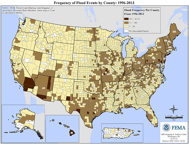
Do you want to have a better understanding of the flood risk you and your community face? Below is a map of the United States, which depicts all coastal, flash, lakeshore, storm surge, or other flooding identified by the National Oceanic and Atmospheric Administration (NOAA) by county since 1996.
Map Information: This is a map of the continental United States, Puerto Rico, Alaska, and Hawaii including state boundaries. It is entitled “Frequency of Flood Events by County: 1996-2013”. It includes data from the NCDC Storm Events database, and includes all events in the database categorized as Costal Flooding, Flooding, Flash Flooding, Lakeshore Flooding, and Storm Surge.

Map Description: The map displays the frequency of recorded floods from 1996-2013 represented by a four point scale. The first and highest frequency group in the scale represents counties with between 101 and 4,114 flood events. The counties with this frequency level cover half of Hawaii and parts of California, Arizona, New Mexico, Texas, Missouri, Indiana, Pennsylvania, New Jersey, and Florida. The second highest frequency group in the scale represents counties with between 21 and 100 flood events. This second frequency level covers the other half of Hawaii and most or part of every state and Puerto Rico, with the exception of Wyoming. The third level of frequency represents counties with between 1 and 20 flood events. This third and lowest frequency level covers part of every state except Hawaii, and parts of Puerto Rico. The fourth and final group in the scale represents counties with no recorded flood events. The areas for this level cover most of Puerto Rico, part of Alaska, and only a few counties in Washington state, Oregon, California, Idaho, Nevada, Utah, Montana, Wyoming, Colorado, New Mexico, North Dakota, Nebraska, Texas, Minnesota, Michigan, Georgia, and South Carolina. In all, approximately 95% of the US is under one of the first three frequency groups with some recorded flooding.
Federal Emergency Management Agency
ORR Mapping and Analysis Center, Washington, D.C., March 13, 2014. Sources: ESRI, USGS.
For more information on protecting yourself from a flood and protecting your property and belongings, download these helpful
- Be Smart- Know Your Alerts and Warnings: The factsheet provides a brief summary of the various alerts and warnings available from Federal, state, local governments as well as the private sector that you can sign up for to stay informed and be ready to take action to be safe.
- Be Smart- Protect Critical Documents and Valuables: The checklist helps you to take an inventory of your household documents (e.g., financial and medical records), contacts, and valuables.
